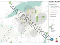
 TSI was the Project Lead for a project that integrated the data collection for the City’s first Pavement Management System (PMS) and ADA Transition Plan. Vehicle mounted high resolution street level photography coupled with GPS location equipment and on-board computer data was used to collect the location of each curb ramp, driveway cut, and sidewalk barrier. The resulting GIS database was used to establish the location of existing facilities and a qualitative assessment of ADA compliance rather than a slope by slope inventory of every curb ramp. The qualitative assessment identified missing curb ramps, hazardous curb ramps, non-compliant but useable curb ramps, and potentially compliant curb ramps. Emphasis was placed on addressing hazardous and missing curb ramps first. This approach was vetted with PSRC and is supported by national publications regarding ADA transition planning. The GIS database was cross-referenced to the City’s Transportation Improvement Program, Pavement Management Program, and current and future users on a proximity basis relating land use and ADA facilities. This approach reduced the initial data collection stage and allowed for identification of barriers to be removed by already planned projects and prioritization of future barrier removals.
 |